


Precision GPS Free
وصف لـPrecision GPS Free
'Precision GPS Free' uses your device's GPS sensor to measure your location more accurately than is possible with typical GPS apps. Turn your phone or tablet into a precision GPS instrument.
Normally, software on your Android device determines your location from individual GPS readings. This is fine if your are interested in getting your location to within about 10 meters. However, it is possible to do better than this if you average many readings at a particular location.
This app is designed to do just that -- average many readings of a stationary Android device to get a more accurate location; it actually calculates a weighted average, accounting for the accuracy of each reading. The trade-off is time. You will need to wait a least a few minutes to get a high accuracy average location.
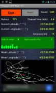
'Precision GPS Free' displays the following information on the main screen:
-'start/stop' button,
-'reset' button,
-battery power remaining as percentage,
-current latitude and longitude,
-round number,
-elapsed time,
-number of GPS satellites in view,
-number of GPS satellites employed in fixing location,
-signal-to-noise ratio of signal from each satellite,
-accuracy of the current readings,
-weighted average (mean) latitude and longitude,
-graph of the current latitude and longitude (white connected points) and the average value (red dot),
-bounding 'scale box' (green) around mean position with a width and a height of 2 meters.
The reset button is inactive while readings are being taken. It can be used after the 'stop' button is pressed. If the measurements are stopped and then started again without pressing the reset button, then only the 'elapsed time' value is reset.
The latitude and longitude values are shown on the graph. North is towards the top and east is toward the right, as in a map. The graph automatically rescales to include the extreme values of longitude and latitude each time it updates the graph (every four seconds). The green scale box is not always square in shape, since the graph latitude scale is not necessarily the same as the graph scale in longitude.
The app times out after 30 seconds if the device cannot get a satellite fix.
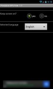
A 'settings' screen provides an option to keep the screen continuously on while the app is running.
Localization language support is provided for French, German, and Spanish.
This app does not save or transmit any personal information, including location or pictures. All the required permissions relate to the GPS operation and the ads.
Applications of 'Precision GPS Free' include navigation, geocaching, prospecting, emergencies, surveying a property, observational astronomy, and archaeology.
A pro version of this app is also available, called 'Precision GPS Pro'. It adds elevation and HDOP, PDOP, VDOP data and options to save the location (and copy to the clipboard), change the interval that readings are taken, display UTM coordinates, display a sky map of the active satellite positions, run in the background, change the format of the coordinates, and send the average coordinates to a mapping app, such as 'Google Maps.' The pro version is also ad-free.
If you have any suggestions for improvements or problem reports, please contact us at ggonzo47@gmail.com.
يستخدم "الدقة GPS الحرة 'جهازك GPS جهاز استشعار لقياس موقعك بدقة أكثر مما هو ممكن مع تطبيقات GPS نموذجية. تحويل هاتفك أو جهازك اللوحي إلى أداة الدقة GPS.
عادة، البرامج على جهاز الروبوت الخاص بك يحدد موقعك من قراءات GPS الفردية. هذا على ما يرام إذا كان لديك مهتما في الحصول على موقعك في حدود نحو 10 مترا. ومع ذلك، فمن الممكن أن تفعل أفضل من ذلك إذا كنت المتوسط العديد من القراءات في موقع معين.
تم تصميم هذا التطبيق لفعل ذلك - متوسط العديد من القراءات من جهاز الروبوت ثابتة للحصول على موقع أكثر دقة. فإنه يحسب في الواقع المتوسط المرجح، وهو ما يمثل دقة كل قراءة. المفاضلة هو الوقت. سوف تحتاج إلى الانتظار لمدة لا يقل عن بضع دقائق للحصول على موقع متوسط درجة عالية من الدقة.
'الدقة GPS الحرة' يعرض المعلومات التالية على الشاشة الرئيسية:
زر -'start / إيقاف،
-'reset 'زر،
قوة البطارية المتبقية كنسبة مئوية،
خطوط الطول والعرض، ولا تزال،
-round العدد،
-الوقت المنقضي،
، عدد من الأقمار الصناعية GPS في الرأي،
، عدد من الأقمار الصناعية GPS المستخدمة في تحديد الموقع،
نسبة -signal إلى الضوضاء إشارة من كل القنوات الفضائية،
-accuracy من القراءات الحالية،
المتوسط -weighted (المتوسط) خطوط الطول والعرض،
-graph من العرض الحالي والعرض (نقطة متصلة بيضاء) ومتوسط قيمة (النقطة الحمراء)،
-bounding "مربع الحجم" (الأخضر) حول المتوسط موقف مع عرض وارتفاع 2 متر.
على زر إعادة الضبط غير نشط في حين يجري اتخاذ القراءات. ويمكن استخدامه بعد الضغط على زر "توقف". إذا توقفت عن القياسات وبعد ذلك بدأ مرة أخرى دون الضغط على زر إعادة الضبط، عندها فقط قيمة 'الوقت المنقضي "تتم إعادة تعيين.
وتظهر قيم خطوط الطول والعرض على الرسم البياني. الشمالية نحو الأعلى والشرق هو نحو اليمين، كما هو الحال في الخريطة. الرسم البياني rescales تلقائيا لتشمل القيم القصوى من خطوط الطول والعرض في كل مرة فإنه يقوم بتحديث الرسم البياني (كل أربع ثوان). المربع الأخضر على نطاق وليس مربعا دائما في الشكل، منذ مقياس الرسم البياني خط العرض ليس بالضرورة نفس مقياس الرسم البياني في الطول.
العصر التطبيق من بعد 30 ثانية إذا كان الجهاز لا يمكن الحصول على قمر صناعي.
توفر شاشة "ضبط" خيار للحفاظ على الشاشة باستمرار أثناء تشغيل التطبيق.
يتم توفير دعم اللغة الترجمة للغة الفرنسية والألمانية والإسبانية.
هذا التطبيق لا يحفظ أو نقل أي معلومات شخصية، بما في ذلك الموقع أو الصور. جميع الأذونات المطلوبة تتعلق العملية GPS والإعلانات.
وتشمل التطبيقات من "الدقة GPS الحرة 'الملاحة، غيوكاشينغ، والتنقيب، وحالات الطوارئ، ومسح الممتلكات، وعلم الفلك الرصدي، وعلم الآثار.
وهناك نسخة المؤيدة لهذا التطبيق هو متاح أيضا، ودعا 'الدقة GPS برو ". وتضيف الارتفاع وHDOP، PDOP، البيانات VDOP والخيارات لحفظ الموقع (ونسخ إلى الحافظة)، تغيير الفاصل الزمني أن تؤخذ القراءات، تنسق عرض UTM، عرض خريطة السماء من المواقف الأقمار الصناعية النشطة، تعمل في الخلفية تغيير شكل إحداثيات، وإرسال الإحداثيات إلى متوسط التطبيق رسم الخرائط، مثل "خرائط جوجل". النسخة الموالية هو أيضا خالية من الاعلانات.
إذا كان لديك أي اقتراحات من أجل إدخال تحسينات أو تقارير مشكلة، يرجى الاتصال بنا على ggonzo47@gmail.com.
Precision GPS Free - إصدار 2.1
(17-12-2018)Precision GPS Free - معلومات APK
نُسخة APK: 2.1الحزمة: com.sciencewithandroid.precisiongpsfreeآخر إصدار من Precision GPS Free


تطبيقات من الفئة نفسها


قد يعجبك أيضًا...


